Filtrer les publications
Simulations of direct and reflected wave trajectories for ground-based GNSS-R experiments
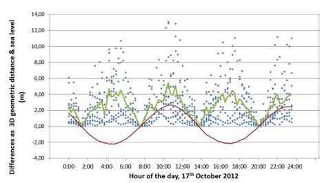
The detection of Global Navigation Satellite System (GNSS) signals that are reflected off the surface, along with the reception of direct GNSS signals, offers a unique opportunity to monitor water level variations over land and ocean. The time delay between the reception of the direct and reflected signals gives access to the altitude of the receiver over the reflecting surface. The field of view of the receiver is highly dependent on both the orbits of the GNSS satellites and the configuration of the study site geometries.
N. Roussel, F. Frappart, G. Ramillien, J. Darrozes, C. Desjardins, P. Gegout, F. Pérosanz, R. Biancale
Date de sortie 02/10/2014
Date de sortie 02/10/2014
Geoscientific Model Development, volume 7
A modeling-based analysis of the flooding associated with Xynthia, central Bay of Biscay
Storm-induced coastal flooding is among the most destructive natural disasters, as seen recently in the Bay of Bengal, the Gulf of Mexico and the Philippines. This study presents a high resolution hindcast of the flooding associated with Xynthia, a mid-latitude storm that severely hit the central part of the Bay of Biscay in February 2010. A 2DH fully coupled modeling system is applied to the North-East Atlantic Ocean, with a resolution locally reaching a few meters along the coastline of the study area.
X. Bertin, K. Li, A. Roland, Y. J. Zhang, J.-F. Breilh, E. Chaumillon
Date de sortie 26/09/2014
Date de sortie 26/09/2014
Coastal Engineering, volume 94

REFMAR : une coordination pour l’observation du niveau de la mer
Le SHOM est le référent national pour l'observation, la gestion et la diffusion des mesures in situ du niveau de la mer.
N. Pouvreau - Equipe REFMAR
Date de sortie 12/09/2014
Date de sortie 12/09/2014
Shom
How frequent is storm-induced flooding in the central part of the Bay of Biscay?
This study analyzes historical archives to produce a database of storm-induced coastal flooding in the French central part of the Bay of Biscay since 1500 AD. From this new database, 46 coastal floods have been reported for the last 500 years (1 event every 11 yr on average), which demonstrates the high vulnerability of this region to coastal flooding. The limitations of historical archives prevent concluding to a change in storminess over the period.
J.-F. Breilh, X. Bertin, E. Chaumillon, N. Giloy, T. Sauzeau
Date de sortie 23/08/2014
Date de sortie 23/08/2014
Global and Planetary Change, volume 122

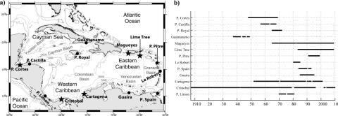
Sea level extremes in the Caribbean Sea
Sea level extremes in the Caribbean Sea are analyzed on the basis of hourly records from 13 tide gauges. The largest sea level extreme observed is 83 cm at Port Spain. The largest nontidal residual in the records is 76 cm, forced by a category 5 hurricane. Storm surges in the Caribbean are primarily caused by tropical storms and stationary cold fronts intruding the basin. However, the seasonal signal and mesoscale eddies also contribute to the creation of extremes.
R. R. Torres, M. N. Tsimplis
Date de sortie 10/07/2014
Date de sortie 10/07/2014
JGR Oceans, volume 119
Applying POT methods to the Revised Joint Probability Method for determining extreme sea levels
Newly exposed concepts of POT declustering (Bernardara et al., 2014) within the GPD-Poisson model are applied to the joint probability of tide and surge for determining extreme sea levels, as a variation of the Revised Joint Probability Method (RJPM, Tawn and Vassie, 1989). A mixture model is proposed for the meteorological residual (surge) component with a non-parametric (empirical) density for the bulk values and parametric models for both the lower and upper tails.
F. Mazas, X. Kergadallan, P. Garat, L. Hamm
Date de sortie 20/06/2014
Date de sortie 20/06/2014
Coastal Engineering, volume 91
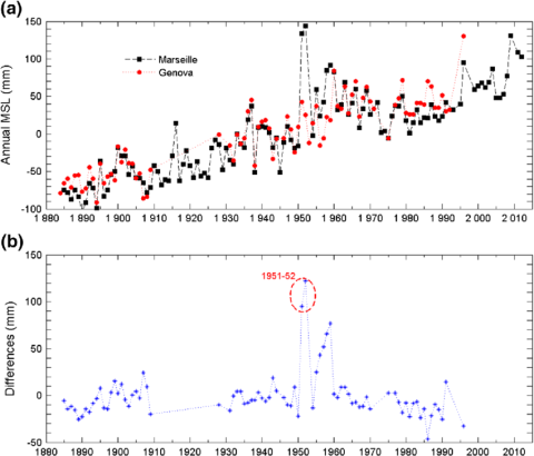
Rescue of the historical sea level record of Marseille (France) from 1885 to 1988 and its extension back to 1849–1851
This paper describes the historical sea level data that we have rescued from a tide gauge, especially devised originally for geodesy. This gauge was installed in Marseille in 1884 with the primary objective of defining the origin of the height system in France. Hourly values for 1885–1988 have been digitized from the original tidal charts. They are supplemented by hourly values from an older tide gauge record (1849–1851) that was rediscovered during a survey in 2009. Both recovered data sets have been critically edited for errors and their reliability assessed.
G. Wöppelmann, M. Marcos, A. Coulomb, B. Martín Míguez, P. Bonnetain, C. Boucher, M. Gravelle, B. Simon, P. Tiphaneau
Date de sortie 08/06/2014
Date de sortie 08/06/2014
Journal of Geodesy, volume 88
Sea-level Science - Understanding Tides, Surges, Tsunamis and Mean Sea-Level Changes
Moving water has a special fascination, and the regular tidal movements of coastal seas must have challenged human imagination from earliest times. Indeed, the ancients who were able to link the regular movements of the sea to the movements of the sun and moon regarded tides as a tangible terrestrial manifestation of the powers of the celestial gods. For them the tides had religious significance; for us there are obviously many practical and scientific reasons for needing to know about and understand the dynamics of the oceans and coastal seas.
D. Pugh, P. Woodworth
Date de sortie 06/2014
Date de sortie 06/2014
Cambridge University Press

New insights on the tsunami recording of the May, 21, 2003, Mw 6.9 Boumerdès earthquake from tidal data analysis
We analyzed sea level data from a set of tide gauge stations located in the central and western Mediterranean Sea, that recorded the tsunami generated by the Mw 6.8 Boumerdès earthquake striking the coast of Algeria on May 21, 2003. This earthquake caused more than 2200 victims and thousands of injured. The causative fault was located a few kilometers offshore and during the rupture a tsunami was triggered. Waves were felt along a large part of the western and northern Mediterranean coasts, and in the Balearic islands waves higher that 2 m were measured.
A. Vecchio, M. Anzidei, V. Carbone
Date de sortie 22/05/2014
Date de sortie 22/05/2014
Journal of Geodynamics, volume 79