Filtrer les publications
Dynamics of CO₂, CH₄, and N₂O in Ria Formosa coastal lagoon (southwestern Iberia) and export to the Gulf of Cadiz
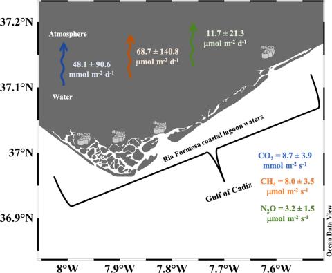
A first characterization of greenhouse gases had been carried out to study their role and impact in a productive transitional coastal system of the southern Portugal – Ria Formosa lagoon. To this purpose, the partial pressure of CO₂ (pCO₂) and the concentration of dissolved CH₄ and N₂O have been measured. Two surveys were carried out during 2020, at low tide under typical conditions of Spring (March) and end of Summer (October).
A. Sierra, C. Correia, T. Ortega, J. Forja, M. Rodrigues, A. Cravo
Date de sortie 19/09/2023
Date de sortie 19/09/2023
Science of The Total Environment, volume 906
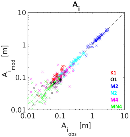
Atmospheric Wind and Pressure-Driven Changes in Tidal Characteristics over the Northwestern European Shelf
Understanding drivers of tidal change is a key challenge in predicting coastal floods in the next century. Whilst interactions between tides and atmospheric surges have been studied, the effects of wind and pressure on tides on an annual scale over the Northwestern European shelf have not been investigated. Here, a modelling approach using the shallow water MARS model is carried out to understand and quantify meteorological effects on tidal characteristics. The model setup is validated against the GESLA 3 tide gauge database.
J. Challis, D. Idier, G. Wöppelmann, G. André
Date de sortie 24/08/2023
Date de sortie 24/08/2023
Journal of Marine Science and Engineering
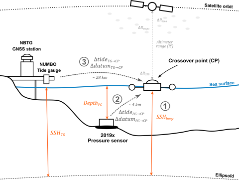
Nouméa: a new multi-mission calibration and validation site for past and future altimetry missions?
Today, monitoring the evolution of sea level in coastal areas is of importance, since almost 11 % of the world's population lives in low-lying areas. Reducing uncertainties in sea level estimates requires a better understanding of both altimetry measurements and local sea level dynamics. In New Caledonia, the Nouméa lagoon is an example of this challenge, as altimetry, coastal tide gauge, and vertical land motions from global navigation satellite systems (GNSSs) do not provide consistent information.
C. Chupin, V. Ballu, L. Testut, Y.-T. Tranchant, J. Aucan
Date de sortie 22/08/2023
Date de sortie 22/08/2023
EGU
Monitoring absolute vertical land motions and absolute sea-level changes from GPS and tide gauges data over French Polynesia
In this study, we estimate the absolute vertical land motions at three tidal stations with collocated Global Navigation Satellite System (GNSS) receivers over French Polynesia during the period 2007–2020, and obtain, as ancillary results, estimates of the absolute changes in sea level at the same locations. To verify our processing approach to determining vertical motion, we first modeled vertical motion at the International GNSS Service (IGS) THTI station located in the capital island of Tahiti and compared our estimate with previous independent determinations, with a good agreement.
X. Li, J.-P. Barriot, B. Ducarme, M. Hopuare, Y. Lou
Date de sortie 08/08/2023
Date de sortie 08/08/2023
Geodesy and Geodynamics, volume 15
![The five archipelagoes in French Polynesia. The locations of the five geodetic TGs are shown as orange point. (Figure is taken from J.P. Barriot et al. [5].).](/sites/default/files/styles/large/public/2025-01/polynesia2.jpg?itok=RIpjQEAg)
Estimation of skew surge uncertainties when predicting tides in the past
The study of storm surges and more generally of extreme events is a subject of growing interest in the current context of coastal risk management in a changing climate. Recent studies show that the consideration of past events improves statistical models. In this context, important investigations have been carried out in the last decade to retrieve and quantify water levels and skew surges associated with historical events for the 18th or 19th century.
N. Giloy, A. Latapy, G. André
Date de sortie 04/08/2023
Date de sortie 04/08/2023
Weather and Climate Extremes, volume 41
Barotropic and baroclinic tides increase primary production on the Northwest European Shelf
High biological productivity and the efficient export of carbon-enriched subsurface waters to the open ocean via the continental shelf pump mechanism make mid-latitude continental shelves like the northwest European shelf (NWES) significant sinks for atmospheric CO2. Tidal forcing, as one of the regionally dominant physical forcing mechanisms, regulates the mixing-stratification status of the water column that acts as a major control for biological productivity on the NWES.
J. Kossack, M. Mathis, U. Daewel, Y. J. Zhang, C. Schrum
Date de sortie 10/07/2023
Date de sortie 10/07/2023
Frontiers in Marine Science
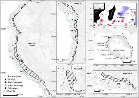
Negative sea level anomalies with extreme low tides in the South-West Indian Ocean shape Reunion Island’s fringing coral reef flats
Among induced mass-mortality events on coral reef, extreme low tides may ultimately lead to considerable reef community deaths on intertidal reef flats due to unusually long and significant aerial exposure. Here, we report an extensive coral mortality event induced by a negative sea level anomaly (nSLA) that occurred across Reunion Island during the austral winter season between June and October 2015 preceding the 2015–2016 El Niño Southern Oscillation (ENSO) event. The nSLA was strong and long in duration with a rapid drop of 35 cm in the mean sea level over a one-month period.
L. Hoarau, P. Mouquet, M. Ropert, A. Cuvillier, L. Massé, S. Bonhommeau, L. Bigot, B. Cauvin, K. Pothin, T. Bajjouk
Date de sortie 21/06/2023
Date de sortie 21/06/2023
Ecological Indicators, volume 154
Les observatoires marégraphiques de Marseille et Brest labellisés par l'Organisation météorologique mondiale
Le 19e Congrès de l’Organisation météorologique mondiale (OMM) se tenait à Genève du 22 mai au 2 juin 2023. Confirmant la reconnaissance de l’UNESCO, les marégraphes de Brest et de Marseille ont été labellisés par l’OMM comme stations d'observation marine centenaires et stations d’observation à long terme.
Date de sortie 13/06/2023
IGN - Shom
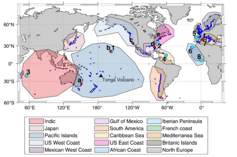
Observational study of the heterogeneous global meteotsunami generated after the Hunga Tonga–Hunga Ha'apai Volcano eruption
The Hunga Tonga–Hunga Ha’apai volcano eruption of January 15th 2022 generated a global atmospheric and oceanic response that was recorded by an unprecedented amount of sensors. The eruption caused an atmospheric perturbation that travelled as a Lamb wave surrounding the Earth at least 3 times, and was recorded by hundreds of barographs worldwide. The atmospheric wave showed complex patterns of amplitude and spectral energy content, although most of the energy was concentrated in the band (2–120 min).
J. Villalonga, À. Amores, S. Monserrat, M. Marcos, D. Gomis, G. Jordà
Date de sortie 27/05/2023
Date de sortie 27/05/2023
Scientific Reports