Filtrer les publications
Coastal flooding of urban areas by overtopping: dynamic modelling application to the Johanna storm (2008) in Gâvres (France)
Recent dramatic events have allowed significant progress to be achieved in coastal flood modelling over recent years. Classical approaches generally estimate wave overtopping by means of empirical formulas or 1-D simulations, and the flood is simulated on a DTM (digital terrain model), using soil roughness to characterize land use. The limits of these methods are typically linked to the accuracy of overtopping estimation (spatial and temporal distribution) and to the reliability of the results in urban areas, which are places where the assets are the most crucial.
S. Le Roy, R. Pedreros, C. André, F. Paris, S. Lecacheux, F. Marche, C. Vinchon
NHESS, volume 15
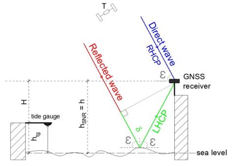
Sea level monitoring and sea state estimate using a single geodetic receiver
GNSS-Reflectometry (GNSS-R) altimetry has demonstrated a strong potential for sea level monitoring. Interference Pattern Technique (IPT) based on the analysis of the Signal-to-Noise Ratio (SNR) estimated by a GNSS receiver, presents the main advantage of being applicable everywhere by using a single geodetic antenna and receiver, transforming them to real tide gauges. Classical SNR analysis method used to estimate the variations of the reflecting surface height h(t) has a limited domain of validity due to its variation rate (dh/dt)(t) assumed to be negligible.
N. Roussel, G. Ramillien, F. Frappart, J. Darrozes, A. Gay, R. Biancale, N. Striebig, V. Hanquiez, X. Bertin, D. Allain
Date de sortie 05/11/2015
Date de sortie 05/11/2015
Remote Sensing of Environment, volume 171
Estimation des niveaux marins extrêmes avec et sans l’action des vagues le long du littoral métropolitain
Pour caractériser le risque de submersion marine, il est très important d'avoir une connaissance précise des lois de distribution des niveaux d'eau marins, et plus particulièrement des niveaux d'eau extrêmes. En effet ce sont eux qui sont à l'origine des conséquences les plus dramatiques. Le programme de recherche mené au cours de cette thèse a été financé par le Ministère de l'Écologie, du Développement Durable et de l'Énergie.
X. Kergadallan
Date de sortie 01/10/2015
Date de sortie 01/10/2015
Laboratoire d'Hydraulique Saint-Venant - Université Paris-Est
Wave spectra partitioning and long term statistical distribution
A new method is presented for a physically based statistical description of wind wave climatology. The method applies spectral partitioning to identify individual wave systems (partitions) in time series of 2D-wave spectra, followed by computing the probability of occurrence of their (peak) position in frequency–direction space. This distribution can be considered as a spectral density function to which another round of partitioning is applied to obtain spectral domains, each representing a typical wave system or population in a statistical sense.
J. Portilla-Yandún, L. Cavaleric, G. Ph. Van Vledder
Date de sortie 27/06/2015
Date de sortie 27/06/2015
Ocean Modelling, volume 96

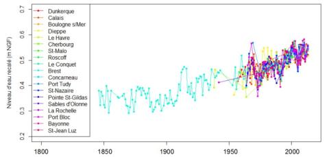
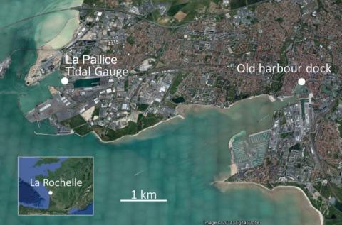
How historical information can improve estimation and prediction of extreme coastal water levels: application to the Xynthia event at La Rochelle (France)
The knowledge of extreme coastal water levels is useful for coastal flooding studies or the design of coastal defences. While deriving such extremes with standard analyses using tide-gauge measurements, one often needs to deal with limited effective duration of observation which can result in large statistical uncertainties. This is even truer when one faces the issue of outliers, those particularly extreme values distant from the others which increase the uncertainty on the results.
T. Bulteau, D. Idier, J. Lambert, M. Garcin
Date de sortie 05/06/2015
Date de sortie 05/06/2015
NHESS, volume 15
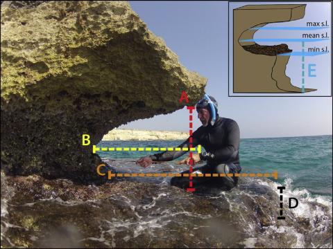
Tidal notches in Mediterranean Sea: a comprehensive analysis
Recent works (Evelpidou et al., 2012) suggest that the modern tidal notch is disappearing worldwide due sea level rise over the last century. In order to assess this hypothesis, we measured modern tidal notches in several of sites along the Mediterranean coasts. We report observations on tidal notches cut along carbonate coasts from 73 sites from Italy, France, Croatia, Montenegro, Greece, Malta and Spain, plus additional observations carried outside the Mediterranean.
F. Antonioli, V. Lo Presti, A. Rovere, L. Ferranti, M. Anzidei, S. Furlani, G. Mastronuzzi, P. E. Orru, G. Scicchitano, G. Sannino, C. R. Spampinato, R. Pagliarulo, G. Deiana, E. de Sabata, P. Sansò, M. Vacchi, A. Vecchio
Date de sortie 15/05/2015
Date de sortie 15/05/2015
Quaternary Science Reviews, volume 119
Diet of Haplognathia ruberrima (Gnathostomulida) in a Caribbean marine mangrove
Haplognathia ruberrima is a cosmopolitan gnathostomulid species found in sulfur bacterial mats in mangroves in Guadeloupe (French West Indies). Haplognathia ruberrima presents a δ13C value lower than all measured meiofaunal grazers and lower than the available measured food sources of this environment. This low δ13C value can not be due to specific ingestion of 13C-depleted methanogenic bacteria because abundances of those bacteria are reduced in surficial and deep sediments as revealed by δ13C of bacterial fatty acid.
P.-Y. Pascal, C. Bellemare, W. Sterrer, H. T. S. Boschker, S. Gonzalez-Rizzo, O. Gros
Date de sortie 29/04/2015
Date de sortie 29/04/2015
Marine Ecology, volume 36
Regional circulation around New Caledonia from two decades of observations
The regional and near-coastal circulation around New Caledonia is investigated using a compilation of more than 20 years of observations. Velocity profiles acquired by Shipboard Acoustic Doppler Current Profiler (SADCP) during 109 research cruises and ship transits since 1991 are analyzed and compared with absolute geostrophic currents inferred from hydrographic profiles and Argo floats drifts. In addition, altimetric surface currents are used to explore the variability of the circulation at various timescales.
S. Cravatte, E. Kestenare, G. Eldin, A. Ganachaud, J. Lefèvre, F. Marin, C. Menkes, J. Aucan
Date de sortie 01/04/2015
Date de sortie 01/04/2015
Journal of Marine Systems, volume 148

A new hybrid model for filling gaps and forecast in sea level: application to the eastern English Channel and the North Atlantic Sea (western France)
This research is carried out in the framework of the program Surface Water and Ocean Topography (SWOT) which is a partnership between NASA and CNES. Here, a new hybrid model is implemented for filling gaps and forecasting the hourly sea level variability by combining classical harmonic analyses to high statistical methods to reproduce the deterministic and stochastic processes, respectively.
I. Turki, B. Laignel, N. Kakeh, L. Chevalier, S. Costa
Date de sortie 12/03/2015
Date de sortie 12/03/2015
Ocean Dynamics, volume 65