Filtrer les publications
Coastal planning should be based on proven sea level data
There are two related measures of sea level, the absolute sea level, which is the increase in the sea level in an absolute reference frame, and relative sea level, which is the increase in sea level recorded by tide gauges. The first measure is a rather abstract computation, far from being reliable, and is preferred by activists and politicians for no scientific reason. For local and global problems it is better to use local tide gauge data. Proper coastal management should be based on proved measurements of sea level.
A. Parker, C. D. Ollier
Ocean & Coastal Management, volume 124
Hyper-resolution mapping of regional storm surge and tide flooding: comparison of static and dynamic models
Storm tide (combination of storm surge and the astronomical tide) flooding is a natural hazard with significant global social and economic consequences. For this reason, government agencies and stakeholders need storm tide flood maps to determine population and infrastructure at risk to present and future levels of inundation. Computer models of varying complexity are able to produce regional-scale storm tide flood maps and current model types are either static or dynamic in their implementation.
J. A. Ramirez, M. Lichter, T. J. Coulthard, C. Skinner
Date de sortie 06/02/2016
Date de sortie 06/02/2016
Natural Hazards
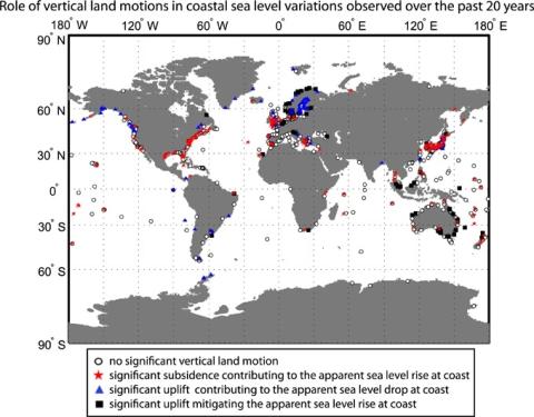
The key role of vertical land motions in coastal sea level variations: A global synthesis of multisatellite altimetry, tide gauge data and GPS measurements
This study aims to quantify the vertical motions driving the decadal coastline mobility and their uncertainty at global scale. Multisatellite altimetry is combined with tide gauges and Global Positioning System (GPS) observations to evaluate the marine and crustal components of relative sea level variations. Vertical land motions and sea level variations are estimated simultaneously over the past 20 years for a network of 886 ground stations, with accuracies better than 1.7 mm/yr.
J. Pfeffer, P. Allemand
Date de sortie 03/02/2016
Date de sortie 03/02/2016
Earth and Planetary Science Letters, volume 439
Estimation of insurance-related losses resulting from coastal flooding in France
A model has been developed in order to estimate insurance-related losses caused by coastal flooding in France. The deterministic part of the model aims at identifying the potentially flood-impacted sectors and the subsequent insured losses a few days after the occurrence of a storm surge event on any part of the French coast. This deterministic component is a combination of three models: a hazard model, a vulnerability model, and a damage model.
J. P. Naulin, D. Moncoulon, S. Le Roy, R. Pedreros, D. Idier, C. Oliveros
Date de sortie 20/01/2016
Date de sortie 20/01/2016
NHESS, volume 16
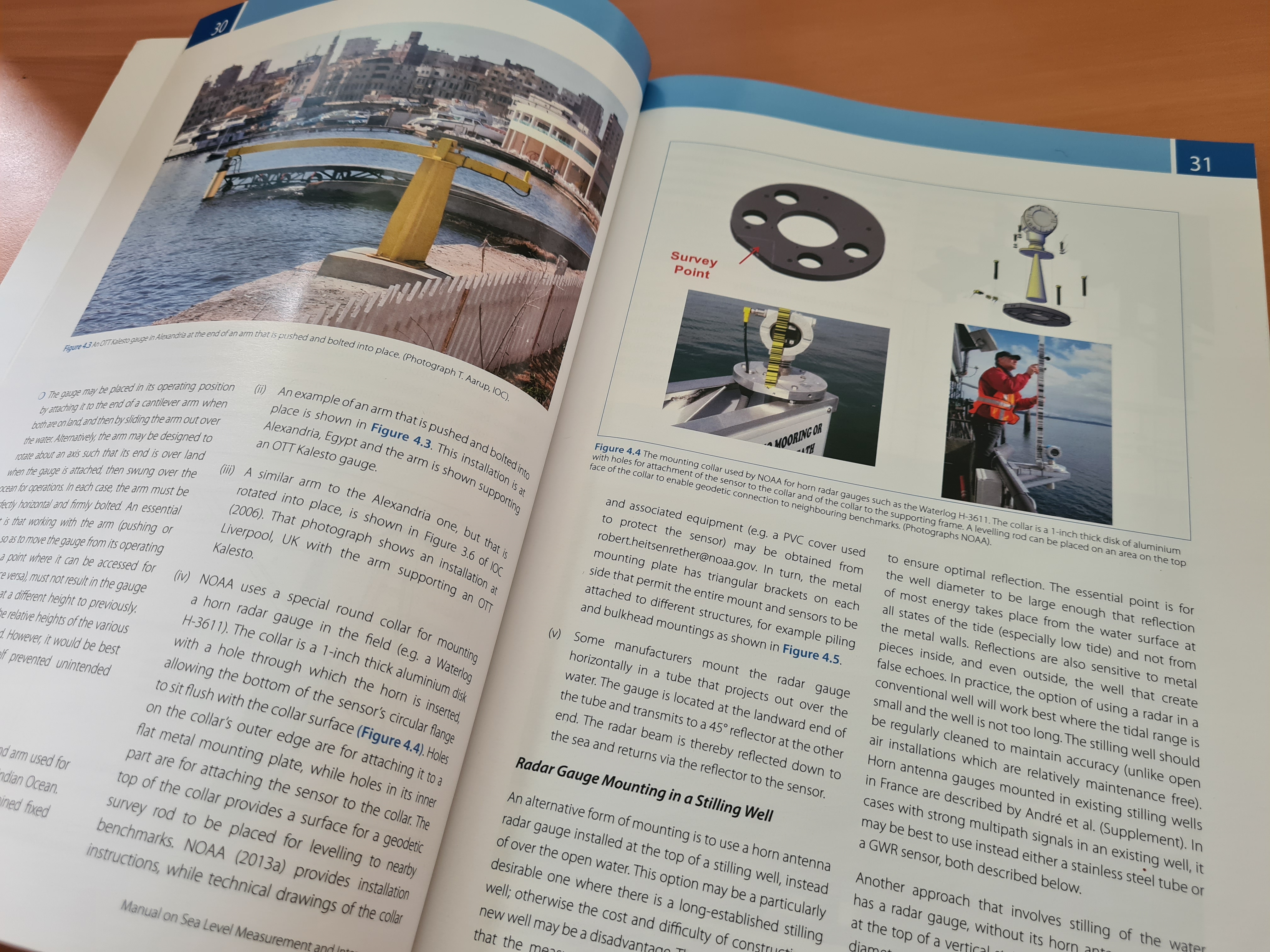
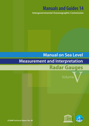
Manual on sea level measurements and interpretation - Volume V - Radar gauges
Radar water level sensors provide several advantages over the older water level instruments. They require less effort to install than float-well, bubbler, or pressure sensor systems. Radar sensors require less maintenance than traditional water-level sensors because they are not in contact with the water. Because radar is a “non-contact” measurement method, it is not susceptible to being obstructed by sediment or debris and does not require that sediment be flushed from a stilling well. Radar water-level sensors may not work at all sites.
Commission océanographique intergouvernementale
Date de sortie 2016
Date de sortie 2016
UNESCO
Manuel sur la mesure et l'interprétation du niveau de la mer - Volume V - Marégraphes radar
Le volume V est spécifiquement consacré aux marégraphes radar. Les télémètres radar sont utilisés depuis de nombreuses années dans les secteurs de l’industrie (afin de mesurer les niveaux des liquides dans les cuves) et de l’hydrologie (afin de mesurer le niveau des cours d’eau, des plans d’eau et des réservoirs).
Commission océanographique intergouvernementale
Date de sortie 2016
Date de sortie 2016
UNESCO
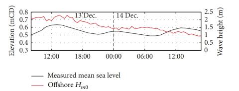
Monitoring individual wave characteristics in the inner surf with a 2-Dimensional laser scanner (LiDAR)
This paper presents an investigation into the use of a 2-dimensional laser scanner (LiDAR) to obtain measurements of wave processes in the inner surf and swash zones of a microtidal beach (Rousty, Camargue, France). The bed is extracted at the wave-by-wave timescale using a variance threshold method on the time series. Individual wave properties were then retrieved from a local extrema analysis. Finally, individual and averaged wave celerities are obtained using a crest-tracking method and cross-correlation technique, respectively, and compared with common wave celerity predictors.
K. Martins, C. E. Blenkinsopp, J. Zang
Date de sortie 06/12/2015
Date de sortie 06/12/2015
Journal of Sensors, Sensors for Coastal Monitoring
Determination of extreme sea levels along the Iberian Atlantic coast
Extreme sea levels along the Atlantic Iberian coast are determined through the development and application of a numerical model for tides and surges, followed by a statistical analysis of the model results. A recent statistical method is assessed using 131 years of data from the Brest tide gauge, and the number of years of data required for an accurate statistical analysis is estimated. The statistical method is extended to consider tide–surge interactions, but they are shown to be small in the study region.
A. B. Fortunato, K. Li, X. Bertin, M. Rodrigues, B. Martín Míguez
Date de sortie 05/12/2015
Date de sortie 05/12/2015
Ocean Engineering, volume 111

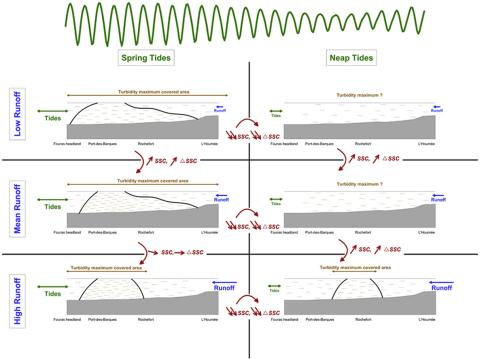
Formation and structure of the turbidity maximum in the macrotidal Charente estuary (France): Influence of fluvial and tidal forcing
Understanding estuarine sediment dynamics and particularly turbidity maximum dynamics is crucial for the management of these coastal systems. Various processes impact the formation, movement and structure of the turbidity maximum. Several studies have shown that tidal asymmetry and density gradients are responsible for the presence of this suspended sedimentary mass.
F. Toublanc, I. Brenon, T. Coulombier
Date de sortie 28/11/2015
Date de sortie 28/11/2015
Estuarine, Coastal and Shelf Science, volume 169