Filtrer les publications
Linking sea level dynamic and exceptional events to large-scale atmospheric circulation variability: A case of the Seine Bay, France
In this study, the multi-time-scale variability of the South English Channel (case of the Seine Bay, North France) sea level and its exceptional events have been investigated in relation with the global climate patterns by the use of wavelet multi-resolution decomposition techniques. The analysis has been focused on surges demodulating by an envelope approach.
I. Turki, N. Massei, B. Laignel
Date de sortie 01/02/2019
Date de sortie 01/02/2019
Oceanologia, volume 61
New Experimental Low Cost Technique of Sea-Level Monitoring: Toward a Sea-Level Monitoring for All
In this paper, we proposed a new low cost technique of sea-level observation and monitoring inspired by the classical Tide Pole (Tide Staff). The results obtained by our proposed High Frequency Rotational Tide Gauge (RTGHF) are promising. They show that RTGHF is very adapted to an agitated environment and is able to measure high and low frequencies oscillations (waves/swells, infragravity waves, seiches, meteotsunamis, tsunamis, tides, sea-level change, etc.).
Y. Hemdane, M. Bouhmadouche, B. Hamadache, M. Aounallah
Date de sortie 18/01/2019
Date de sortie 18/01/2019
Patterns and Mechanisms of Climate, Paleoclimate and Paleoenvironmental Changes from Low-Latitude Regions, CAJG 2018, Advances in Science, Technology & Innovation, pp149-151 - Springer, Cham

Vertical land motion and relative sea level changes along the coastline of Brest (France) from combined space-borne geodetic methods
In spite of the recent advances and the current perspectives of satellite radar altimetry to reach the coastline and monitor coastal sea level changes, this space-borne technology remains geocentric by essence. In contrast, the quantity that matters for coastal management and society is relative sea level. That is, the sea level relative to the land, as measured by conventional tide gauges. However, two important issues are associated with the use of tide gauges.
C. Poitevin, G. Wöppelmann, D. Raucoules, G. Le Cozannet, M. Marcos, L. Testut
Date de sortie 09/01/2019
Date de sortie 09/01/2019
Remote Sensing of Environment, volume 222

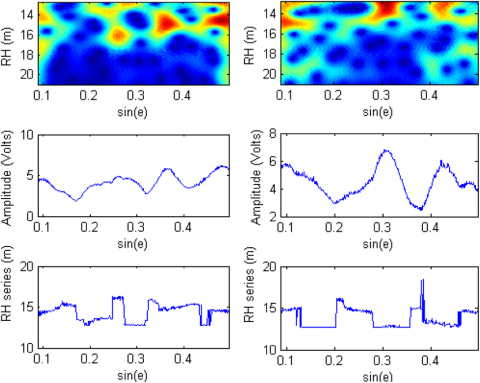
Sea level estimation from SNR data of geodetic receivers using wavelet analysis
Previous studies have proved that commercial, off-the-shelf, geodetic-quality Global Positioning System (GPS) receivers can monitor water level using multipath interferometric characteristics from the sea surface. A Lomb–Scargle periodogram (LSP) is typically used to extract the multipath frequency from the signal-to-noise ratio (SNR), which relates to the vertical distance between the antenna phase center and the reflecting surface, and subsequently, estimate sea levels.
X. Wang, Q. Zhang, S. Zhang
Date de sortie 01/11/2018
Date de sortie 01/11/2018
GPS Solutions, volume 23, article 6
Sedimentary Dynamics and Decadal-Scale Changes in the Macrotidal Aulne River Estuary, Brittany, France
Studies of macrotidal estuaries have been dominated by large, high-turbidity systems like the Gironde and Severn, but some macrotidal estuaries are different from these systems. The goal of this study was to document the state of hydrosedimentary processes in the macrotidal, low-turbidity Aulne River estuary and, where possible, compare it to a previous study. Study sites from a 1977 study were revisited in 2013. Observations of velocity, salinity, and suspended sediment concentration were analyzed and compared to the 1977 study, with particular attention given to hourly data.
S. Moskalski, F. Floc'h, R. Verney, G. Fromant, N. Le Dantec, A. Deschamps
Date de sortie 01/11/2018
Date de sortie 01/11/2018
Journal of Coastal Research, volume 34

Time variability of hydrodynamics and potential use of surface water and ocean topography mission in estuarine macrotidal system: example of Seine estuary
L. Chevalier, B. Laignel, I. Turki, F. Lyard, C. Lion
Date de sortie 27/07/2018
Date de sortie 27/07/2018
Journal of Applied Remote Sensing, volume 12

Wind effect on bottom shear stress, erosion and redeposition on Zostera noltei restoration in a coastal lagoon; part 2
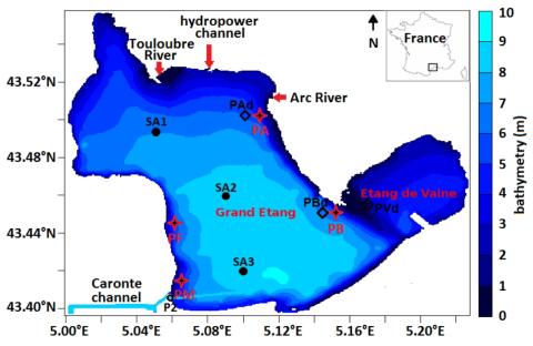
This paper concerns wind effect on bottom shear stress (BSS), resuspension and redeposition of bottom sediments in the nearshore areas of the Etang de Berre (EB), a semi-enclosed lagoon, in the context of Zostera noltei (Z.n.) restoration. As in our previous paper, the first step is to compare BSS with its threshold, BSScr, for a wind speed of 21 m/s. But, here, a new simulation is performed for 16 wind directions regularly spaced. It permits to analyze the combined effect, over one year, of these winds on the erosion risk.
E. Alekseenko, B. Roux
Date de sortie 24/05/2018
Date de sortie 24/05/2018
Estuarine, Coastal and Shelf Science, volume 216
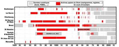
Évolution du rivage et des petits-fonds du littoral du Nord de la France depuis le 19ème siècle
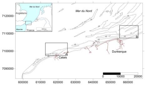
La façade nord des Hauts-de-France correspond à une frange côtière de 60 km orientée OSO-ENE ouverte sur la mer du Nord. De nombreux bancs sableux sont présents le long de ce littoral où ils forment des corps sédimentaires massifs parallèles à obliques au trait de côte, localisés sur l’avant-côte jusqu’à plusieurs dizaines de mètres de profondeur. Des levés bathymétriques ont été exécutés depuis les années 1830 dans cette région. Les résultats de ces levés hydrographiques sont conservés au format papier dans les archives du Shom.
A. Latapy, A. Hequette, N. Pouvreau, N. Weber
Date de sortie 05/2018
Date de sortie 05/2018
Paralia - XVème Journées Nationales Génie Côtier – Génie Civil, La Rochelle
Intérêt du "Data-Rescue" en marégraphie : des archives papiers à l’étude de l’évolution du niveau marin. Exemple de la reconstruction de la série marégraphique de Saint-Nazaire depuis le 19ème siècle
La hausse du niveau de la mer liée aux changements climatiques globaux demeure l'une des préoccupations sociétales majeures. L'analyse des données marégraphiques, constituant souvent les seules informations disponibles à l’échelle des décennies, voire des siècles passés, se révèle être un moyen idéal pour parvenir à dégager des tendances sur le long terme. Or, malgré un patrimoine historique marégraphique français conséquent, la majorité de ces mesures est encore sous forme papier et n’est donc pas exploitée.
Y. Ferret Y., S. Lorrette-Riberolles, V. Donato, N. Pouvreau
Date de sortie 05/2018
Date de sortie 05/2018
Paralia - XVèmes Journées Nationales Génie Côtier - Génie Civil, La Rochelle