Filtrer les publications
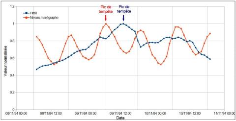
Nonlinear dynamics of the sea level time series in the eastern English Channel
Coastal flooding due to surge events represents natural hazards with huge potential consequences for coastal regions. Sea level time series display variations on a large range of timescales, with a deterministic component associated with tidal variations and a stochastic component primarily associated with meteorological forcing, the non-tidal residual. The deterministic component can be evaluated using a model taking into account astronomical forcing and topographic information.
F. G. Schmitt, A. Crapoulet, A. Hequette, Y. Huang
Natural Hazards, volume 91
Investigating the impacts of the regression of Posidonia oceanica on hydrodynamics and sediment transport in Giens Gulf
Posidonia oceanica plays a significant role in the stabilization and protection of the coast in Gulf of Giens. Unfortunately, its distribution has been declining remarkably due to both anthropogenic interventions and natural factors. The present study focuses on the numerical simulation of the presence of Posidonia as well as the influence of its disappearance on hydrodynamics and sediment transport along Alamanarre beach.
M. Tuan Vu, Y. Lacroix, V. T. Nguyen
Date de sortie 30/09/2017
Date de sortie 30/09/2017
Ocean Engineering, volume 146

Historical Sea Level in the South Pacific from Rescued Archives, Geodetic Measurements, and Satellite Altimetry
Automatic sea-level measurements in Nouméa, South Pacific, started in 1957 for the International Geophysical year. Data from this location exist in paper record for the 1957–1967 period, and in two distinct electronic records for the 1967–2005 and 2005–2015 period. In this study, we digitize the early record, and established a link between the two electronic records to create a unique, nearly 60 year-long instrumental sea-level record. This work creates one of the longest instrumental sea-level records in the Pacific Islands.
J. Aucan, M. A. Merrifield, N. Pouvreau
Date de sortie 21/08/2017
Date de sortie 21/08/2017
Pure and Applied Geophysics, volume 174, pp3813–3823
Managed realignment to mitigate storm-induced flooding: A case study in La Faute-sur-mer, France
Storm-induced coastal flooding is among the most destructive natural disasters while climate change together with increased populations along the coast will enhance the associated risk. This study presents the comparison of conventional coastal defense schemes against managed realignment schemes in La Faute-sur-Mer, a small village located in the central part of the Bay of Biscay that was severely impacted during Xynthia in 2010.
J.-R. Huguet, X. Bertin, G. Arnaud
Date de sortie 19/08/2017
Date de sortie 19/08/2017
Coastal Engineering, volume 134
Analyse des niveaux d'eau avec l'action des vagues au droit d'une plage de Méditerranée
La façade maritime méditerranéenne est bordée par plusieurs départements littoraux sur lesquels des enjeux de gestion du Domaine Public Maritime naturel (DPM) forts existent. La délimitation du DPM est complexe et un éventail de techniques est disponible. Afin d’apporter des éléments d’appréciation, le Cerema s’est penché sur l’approche probabiliste qui vise à estimer l’action des vagues au niveau du rivage à partir des données hydrauliques disponibles. Les périodes de retour associées au niveau d’eau avec l’action des vagues sont étudiées pour une plage à enjeux de Méditerranée.
X. Kergadallan, N. Metzler
Date de sortie 20/03/2017
Date de sortie 20/03/2017
Revue Paralia, volume 10
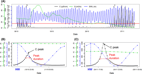
Short-term forecasting of saltwater occurrence at La Comté River (French Guiana) using a kernel-based support vector machine
Saltwater intrusion into rivers is a major concern for freshwater exploitation and management in French Guiana (South America). To detect and analyse saltwater occurrence, a permanent station was installed on La Comté River to measure the electrical conductivity C. The objective of the present study was twofold. First, the temporal link between C, sea water level SWL and river discharge Q was explored during the dry seasons from 2009 to 2012 (total measurement duration of ~6 months). A lag of 3 h between C and SWL was evidenced (i.e.
J. Rohmer, N. Brisset
Date de sortie 18/03/2017
Date de sortie 18/03/2017
Environmental Earth Sciences, volume 76
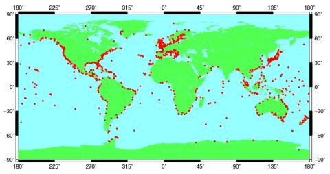
Towards a global higher-frequency sea level dataset
This paper describes the assembly of an updated quasi-global dataset of higher-frequency sea level information obtained from tide gauges operated by many agencies around the world. We believe that the construction of such a dataset is fundamental to scientific research in sea level variability and also to practical aspects of coastal engineering. A first version of the dataset was used in approximately a dozen published studies, and this second version is about twice the size, containing longer and more geographically representative sea level records.
P. L. Woodworth, J. R. Hunter, M. Marcos, P. Caldwell, M. Menéndez, I. Haigh
Date de sortie 24/02/2017
Date de sortie 24/02/2017
Geoscience Data Journal, volume 3
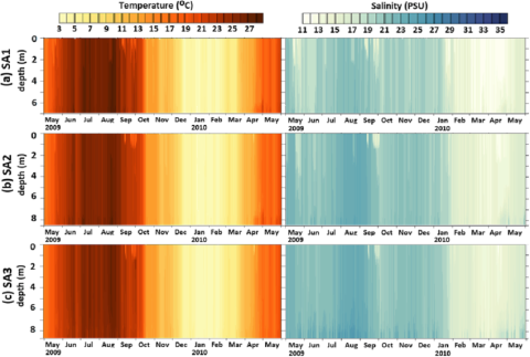
The effect of wind induced bottom shear stress and salinity on Zostera noltii replanting in a Mediteerranean coastal lagoon
The paper concerns the wind influence on bottom shear stress and salinity levels in a Mediterranean semi-enclosed coastal lagoon (Etang de Berre), with respect to a replanting program of Zostera noltii. The MARS3D numerical model is used to analyze the 3D current, salinity and temperature distribution induced by three meteorological, oceanic and anthropogenic forcings in this lagoon. The numerical model has been carefully validated by comparison with daily observations of the vertical salinity and temperature profiles at three mooring stations, for one year.
E. Alekseenko, B. Roux, D. Fougere, P. G. Chen
Date de sortie 31/01/2017
Date de sortie 31/01/2017
Estuarine, Coastal and Shelf Science, volume 187
A case study on the growth of Lanice conchilegas (Pallas, 1766) aggregations and their ecosystem engineering impact on sedimentary processes
Ecosystem engineers are organisms that modulate natural resources enabling the survival of other species. They drive environmental change and contribute to several coastal functional attributes such as landscape heterogeneity, sedimentary processes, and coastal protection. Our study focuses on the case of Lanice conchilega, a tube-building ecosystem engineer whose aggregations impact sedimentary processes. This polychaete forms biogenic tube aggregations distributed on the coasts of the northern hemisphere from the shallow intertidal to depths of 1900 m.
R. M. S. Alves, C. Van Colen, M. Vincx, J. Vanaverbeke, B. de Smet, J.-M. Guarini, M. Rabaut, T. J. Bouma
Date de sortie 21/01/2017
Date de sortie 21/01/2017
Journal of Experimental Marine Biology and Ecology, volume 489