Filtrer les publications
Extension of a high temporal resolution sea level time series at Socoa (Saint-Jean-de-Luz, France) back to 1875
In this data paper, the sea level time series at Socoa (Saint-Jean-de-Luz, southwestern France) is extended through a data archaeology exercise. We conducted a comprehensive study of national and local archives to catalogue water level records stored in ledgers (handwritten record books) and charts (marigrams from mechanical float gauges), along with other associated documents (metadata). A dedicated effort was undertaken to preserve more than 2000 documents by archiving them in digital formats.
M. J. U. Khan, I. Van Den Beld, G. Wöppelmann, L. Testut, A. Latapy, N. Pouvreau
Date de sortie 18/12/2023
Date de sortie 18/12/2023
ESSD
Chronic flooding events due to sea‑level rise in French Guiana
As sea levels are rising, the number of chronic flooding events at high tide is increasing across the world coastlines. Yet, many events reported so far either lack observational evidence of flooding, or relate to coastal areas where ground subsidence or oceanic processes often enhance climate change-induced sea-level rise (SLR). Here we present observational and modelling evidence of high-tide flooding events that are unlikely to occur without SLR in French Guiana, where sea-level rise rates are close to the global average and where there is no significant ground subsidence.
Rémi Thiéblemont, Gonéri Le Cozannet, Maurizio D’Anna, Déborah Idier, Ali Belmadani, Aimée B. A. Slangen & François Longueville
Date de sortie 07/12/2023
Date de sortie 07/12/2023
Scientific reports
XYZ n°177 : Niveau de la mer
Dans ce numéro spécial, une collaboration de l'Association des amis du marégraphe de Marseille et de l'AFT, le lecteur pourra, lui-même, se faire une idée, aussi scientifique que précise, du phénomène. En effet, l'élévation de plus en plus rapide du niveau moyen de la mer est un des indicateurs des changements climatiques anthropiques. Ce numéro aborde donc, grâce à un panel de spécialistes, les techniques de la mesure, du marégraphe aux méthodes spatiales et GNSS puis les corrections de ces mesures pour les rendre indépendantes des mouvements terrestres.
G. André, A. Bailly, J. Chenal, A. Coulomb, B. Flacelière, C. Galpin, T. Landes, J.-P. Maillard, P. Sablayrolles, L. Testut, G. Wöppelmann, M. Ablain, E. Caillaud, C. Fraboul, N. Giloy, H. Hébert, N. Hesse, O. Jamet, D. Jourdan, D. Laplace, A. Latapy, ...
Date de sortie 12/2023
Date de sortie 12/2023
AFT

Des émissions de gaz à effet de serre à l’élévation du niveau de la mer : contraindre la dynamique du bilan d’énergie planétaire par la géodésie spatiale
Les émissions anthropiques de gaz à effet de serre conduisent à l’apparition d’une différence en haut de l’atmosphère entre le flux radiatif solaire reçu par la Terre et le flux radiatif infrarouge émis par la Terre. On appelle cette différence le déséquilibre énergétique planétaire, qui correspond à l’énergie additionnelle stockée par le système climatique. Le déséquilibre énergétique planétaire est donc la cause du réchauffement global.
Jonathan Chenal, Benoît Meyssignac
Date de sortie 12/2023
Date de sortie 12/2023
XYZ n°177
Apport de la gravimétrie absolue à l’estimation du niveau des mers
La mesure et l’étude de la variation du niveau de la mer en zone côtière sont un enjeu scientifique et sociétal majeur. Les mesures marégraphiques montrent des tendances de quelques millimètres par an et doivent être associées à des mesures géodésiques permettant de séparer le signal du niveau de la mer du mouvement vertical continental. Il a été montré que le couplage de mesures GNSS et de gravimétrie absolue améliore la compréhension des signaux marégraphiques.
Marie-Françoise Lequentrec-Lalancette
Date de sortie 12/2023
Date de sortie 12/2023
XYZ n°177
Les activités de reconstruction marégraphique en France
Dans le contexte actuel de changement climatique, l’apport de séries temporelles du niveau de la mer, pluridécennales à séculaires, se révèle primordial pour mieux appréhender les risques côtiers futurs. En France, de nombreuses observations systématiques du niveau de la mer au moyen de marégraphes mécaniques ont été initiées dès le milieu du XIXe siècle. Pour exploiter ces données, il est d’abord nécessaire de numériser ce patrimoine scientifique et culturel et de valider les nouvelles données.
Alexa LATAPY, Inge VAN DEN BELD, Frédéric PONS, Nicolas POUVREAU
Date de sortie 12/2023
Date de sortie 12/2023
XYZ n°177
L’élévation du niveau de la mer et les risques côtiers
L’élévation du niveau de la mer est un processus qui s’est enclenché avec le réchauffement climatique d’origine humaine. Si ce phénomène ne peut plus être raisonnablement arrêté, sa vitesse dépendra des émissions de gaz à effet de serre et de la réponse des calottes de glace au réchauffement climatique. Ainsi, des politiques climat ambitieuses, limitant les émissions de gaz à effet de serre de manière massive et immédiate, peuvent apporter des bénéfices importants pour l’adaptation côtière en rendant possible de nombreuses options.
Gonéri Le Cozannet
Date de sortie 12/2023
Date de sortie 12/2023
XYZ n°177
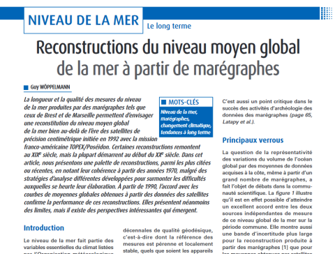
Reconstructions du niveau moyen global de la mer à partir de marégraphes
La longueur et la qualité des mesures du niveau de la mer produites par des marégraphes tels que ceux de Brest et de Marseille permettent d’envisager une reconstitution du niveau moyen global de la mer bien au-delà de l’ère des satellites de précision centimétrique initiée en 1992 avec la mission franco-américaine TOPEX/Poséidon. Certaines reconstructions remontent au XIXe siècle, mais la plupart démarrent au début du XXe siècle. Dans cet
Guy Wöppelmann
Date de sortie 12/2023
Date de sortie 12/2023
XYZ n°177
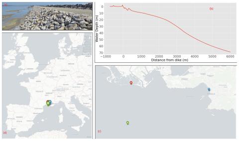
Sensitivity analysis of erosion on the landward slope of an earthen flood defence submitted to wave overtoppings
The study aims to provide a complete analysis framework applied to an earthen dike located in Camargue, France. This dike is regularly submitted to erosion on the landward slope that needs to be repaired. Improving the resilience of the dike calls for a reliable model of damage frequency.
C. Houdard, A. Poupardin, P. Sergent, A. Bennabi, J. Jeong
Date de sortie 27/09/2023
Date de sortie 27/09/2023
NHESS, volume 23