Rechercher
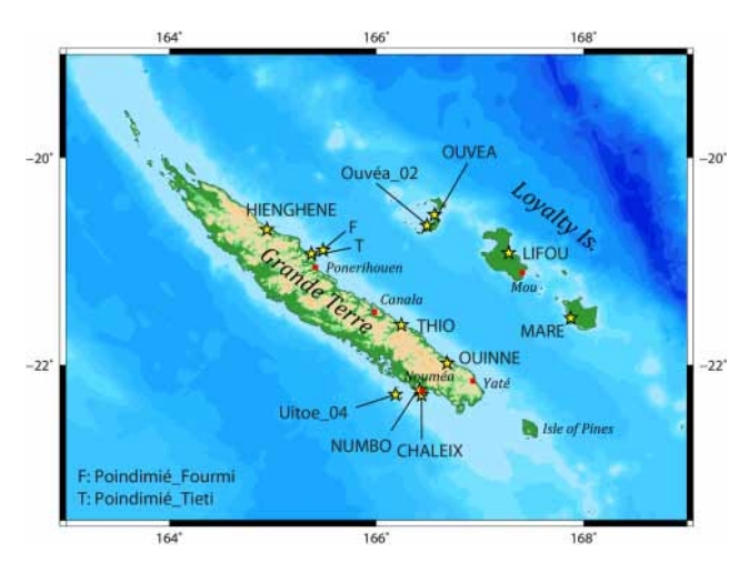
Update of the tsunami catalogue of New Caledonia using a decision table based on seimic data and maregraphic records
Fourteen years ago, the 26 December 2004 Indian Ocean tsunami demonstrated the destructional capability of tsunamis to the entire world. Since then, many research programs have been initiated to…
Vertical land motion and relative sea level changes along the coastline of Brest (France) from combined space-borne geodetic methods
In spite of the recent advances and the current perspectives of satellite radar altimetry to reach the coastline and monitor coastal sea level changes, this space-borne technology remains…

Modélisation déterministe et probabiliste des dommages assurantiels causés par les phénomènes de submersion marine en France métropolitaine
Afin d'anticiper les dommages engendrés par les phénomènes de submersion marine et d'y faire face, CCR a développé un modèle spécifique à ce péril pour la France métropolitaine. Ce modèle présente…
New Experimental Low Cost Technique of Sea-Level Monitoring: Toward a Sea-Level Monitoring for All
In this paper, we proposed a new low cost technique of sea-level observation and monitoring inspired by the classical Tide Pole (Tide Staff). The results obtained by our proposed High Frequency…

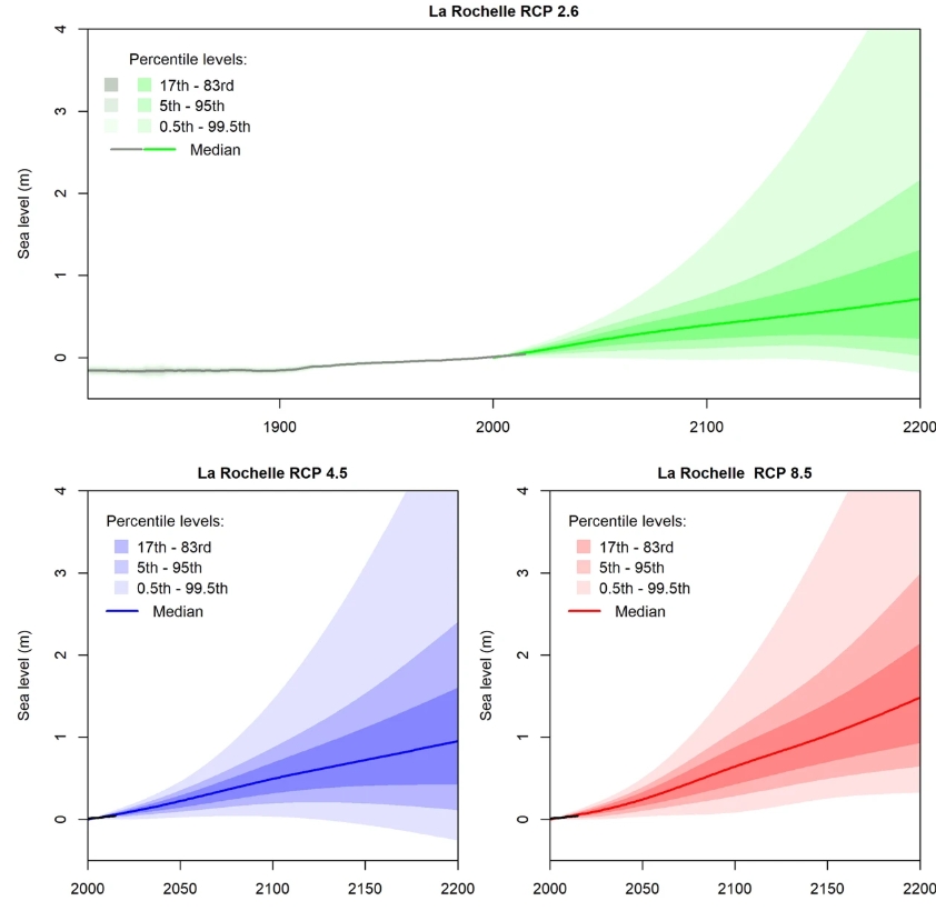
Quantifying uncertainties of sandy shoreline change projections as sea level rises
Sandy shorelines are constantly evolving, threatening frequently human assets such as buildings or transport infrastructure. In these environments, sea-level rise will exacerbate coastal erosion…
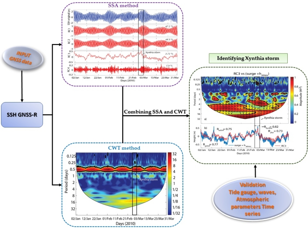
Identifying 2010 Xynthia Storm Signature in GNSS-R-Based Tide Records
In this study, three months of records (January–March 2010) that were acquired by a geodetic Global Navigation Satellite Systems (GNSS) station from the permanent network of RGP (Réseau GNSS…
Decadal-scale Dynamics and Morphological Evolution of Mangroves and Beaches in a Reef-lagoon Complex, Mayotte Island
Mayotte Island is characterized by a vast coral reef-lagoon complex comprising significant mangrove development and numerous pocket beaches nested between volcanic headlands. Since 2005, field…
Characterization of Sea-level Variations Along the Metropolitan Coasts of France: Waves, Tides, Storm Surges and Long-term Changes
With 5853 km of coastlines facing the North Sea, the English Channel, the Atlantic Ocean and the Mediterranean Sea, France displays littoral zones exposed to a wide spectrum of wave climates,…
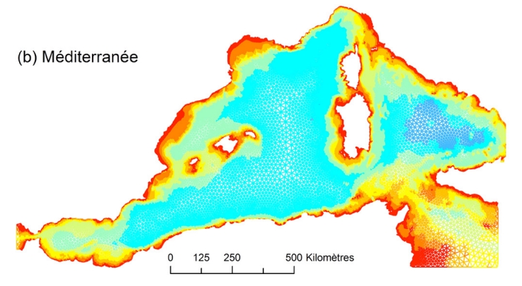
2D and 3D modelling of offshore sandbank dynamics
The coastal zone is an important resource both socially and economically. Globally, coastal zones are under increasing threat from the effects of climate change, erosion and flooding.…
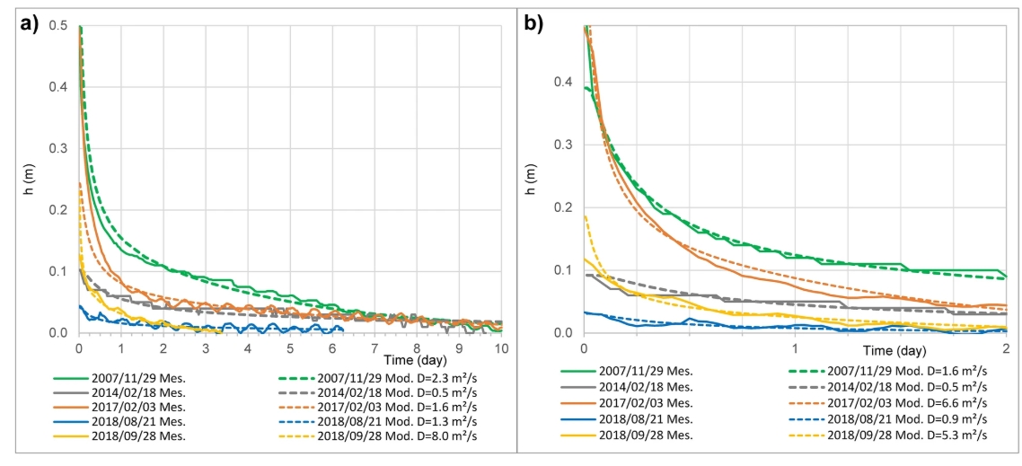
Earthquakes and extreme rainfall induce long term permeability enhancement of volcanic island hydrogeological systems
Earthquakes affect near-surface permeability, however temporal permeability evolution quantification is challenging due to the scarcity of observations data. Using thirteen years of groundwater…