Rechercher
Coastal monitoring solutions of the geomorphological response of beach-dune systems using multi-temporal LiDAR datasets (Vendée coast, France)
Shield volcanoes are described as low-angle edifices built primarily by the accumulation of successive lava flows. This generic view of shield volcano morphology is based on a limited number of…
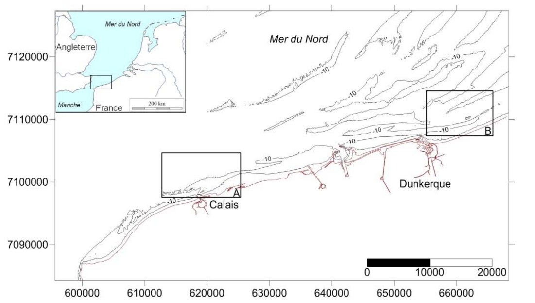
Évolution du rivage et des petits-fonds du littoral du Nord de la France depuis le 19ème siècle
La façade nord des Hauts-de-France correspond à une frange côtière de 60 km orientée OSO-ENE ouverte sur la mer du Nord. De nombreux bancs sableux sont présents le long de ce littoral où ils…
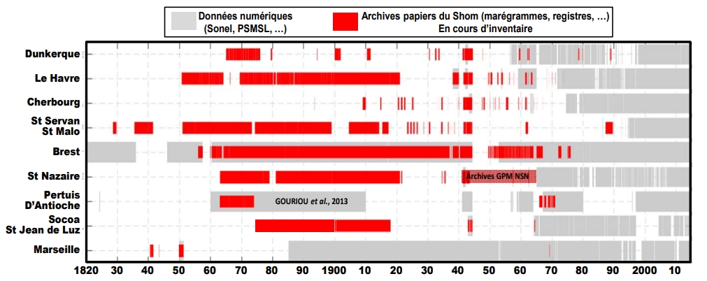
Intérêt du "Data-Rescue" en marégraphie : des archives papiers à l’étude de l’évolution du niveau marin. Exemple de la reconstruction de la série marégraphique de Saint-Nazaire depuis le 19ème siècle
La hausse du niveau de la mer liée aux changements climatiques globaux demeure l'une des préoccupations sociétales majeures. L'analyse des données marégraphiques, constituant souvent les seules…
Time variability of hydrodynamics and potential use of surface water and ocean topography mission in estuarine macrotidal system: example of Seine estuary
This work was supported by the National Center for Space Studies in the framework of the future mission surface water and ocean topography (SWOT). The estuarine zones with their complex…

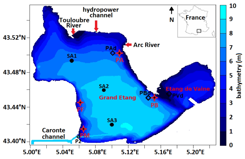
Wind effect on bottom shear stress, erosion and redeposition on Zostera noltei restoration in a coastal lagoon; part 2
This paper concerns wind effect on bottom shear stress (BSS), resuspension and redeposition of bottom sediments in the nearshore areas of the Etang de Berre (EB), a semi-enclosed lagoon, in the…
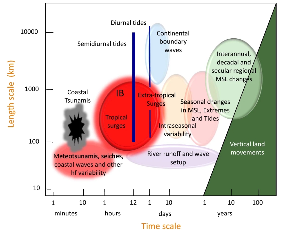
Forcing Factors Affecting Sea Level Changes at the Coast
We review the characteristics of sea level variability at the coast focussing on how it differs from the variability in the nearby deep ocean. Sea level variability occurs on all timescales, with…
Coherent superposition of multi-GNSS wavelet analysis periodogram for sea-level retrieval in GNSS multipath reflectometry
The multipath signals of GNSS can act as a tide gauge via a technology called Global Navigation Satellite Systems multipath reflectometry (GNSS-MR), which is based on the relationship between…

Evaluation and combination of quad-constellation multi-GNSS multipath reflectometry applied to sea level retrieval
The satellites of the Global Navigation Satellite System (GNSS) continuously broadcast L-band signals at about a 20-cm wavelength. Some signal-to-noise ratio (SNR) data received by off-shelf…

Sea level estimation from SNR data of geodetic receivers using wavelet analysis
Previous studies have proved that commercial, off-the-shelf, geodetic-quality Global Positioning System (GPS) receivers can monitor water level using multipath interferometric characteristics from…
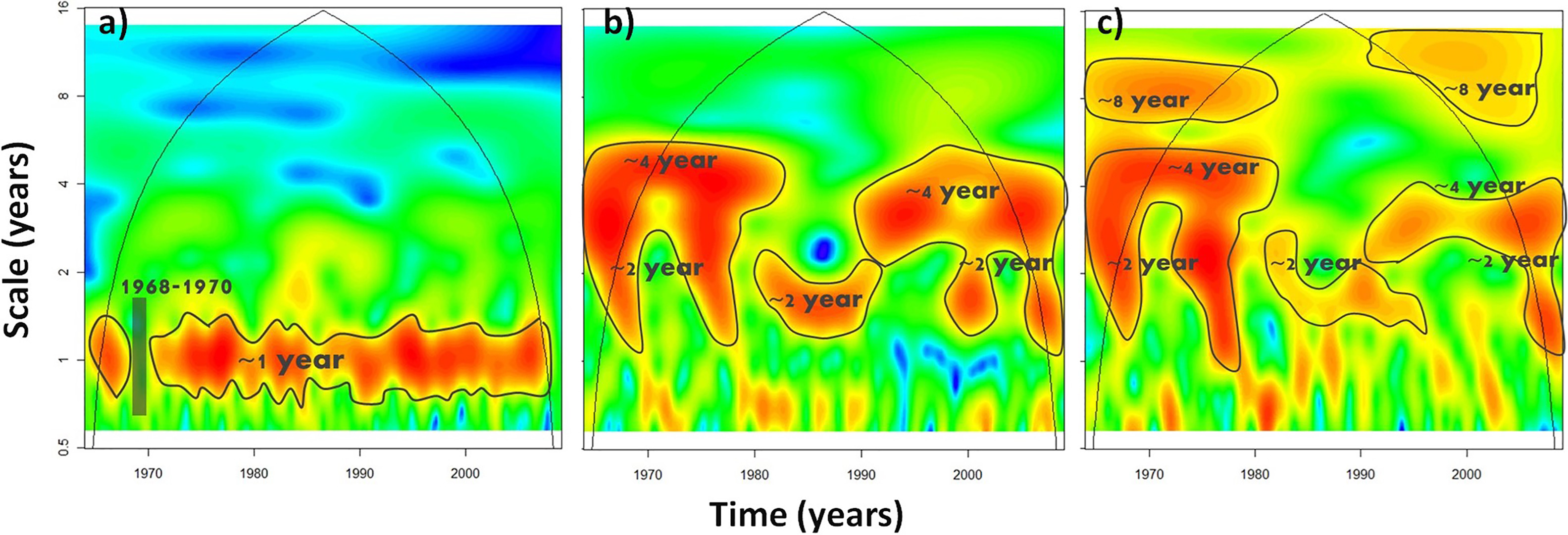
Linking sea level dynamic and exceptional events to large-scale atmospheric circulation variability: A case of the Seine Bay, France
In this study, the multi-time-scale variability of the South English Channel (case of the Seine Bay, North France) sea level and its exceptional events have been investigated in relation with the…