
Rechercher
Lagoon islets as indicators of recent environmental changes in the South Pacific - the New Caledonian example
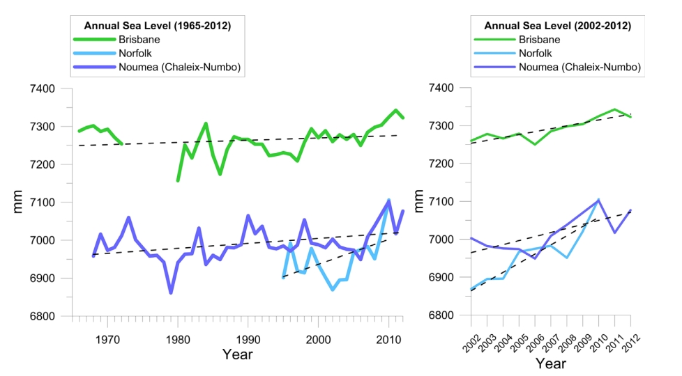
The question of the impacts of climate change and sea level rise on small islands is currently much discussed. The many thousands of Pacific islands in their different contexts (geodynamic,…
Determination of extreme sea levels along the Iberian Atlantic coast
Extreme sea levels along the Atlantic Iberian coast are determined through the development and application of a numerical model for tides and surges, followed by a statistical analysis of the…

Coastal applications from nadir altimetry: example of the X-TRACK regional products
In the coastal ocean zones, satellite altimetry data processing and interpretation poses specific difficulties, due to the interaction of the radar signal with land topography, inaccuracies in…

Satellite radar altimetry water elevations performance over a 200 m river: Evaluation over the Garonne River
For at least 20 years, nadir altimetry satellite missions have been successfully used to first monitor the surface elevation of oceans and, shortly after, of large rivers and lakes. For the last 5…
Investigating the impacts of the regression of Posidonia oceanica on hydrodynamics and sediment transport in Giens Gulf
Posidonia oceanica plays a significant role in the stabilization and protection of the coast in Gulf of Giens. Unfortunately, its distribution has been declining remarkably due to both…