
Rechercher
Azimuth selection for sea level measurements using geodetic GPS receivers
Based on analysis of Global Positioning System (GPS) multipath signals recorded by a geodetic GPS receiver, GPS Reflectometry (GPS-R) has demonstrated unique advantages in relation to sea level…

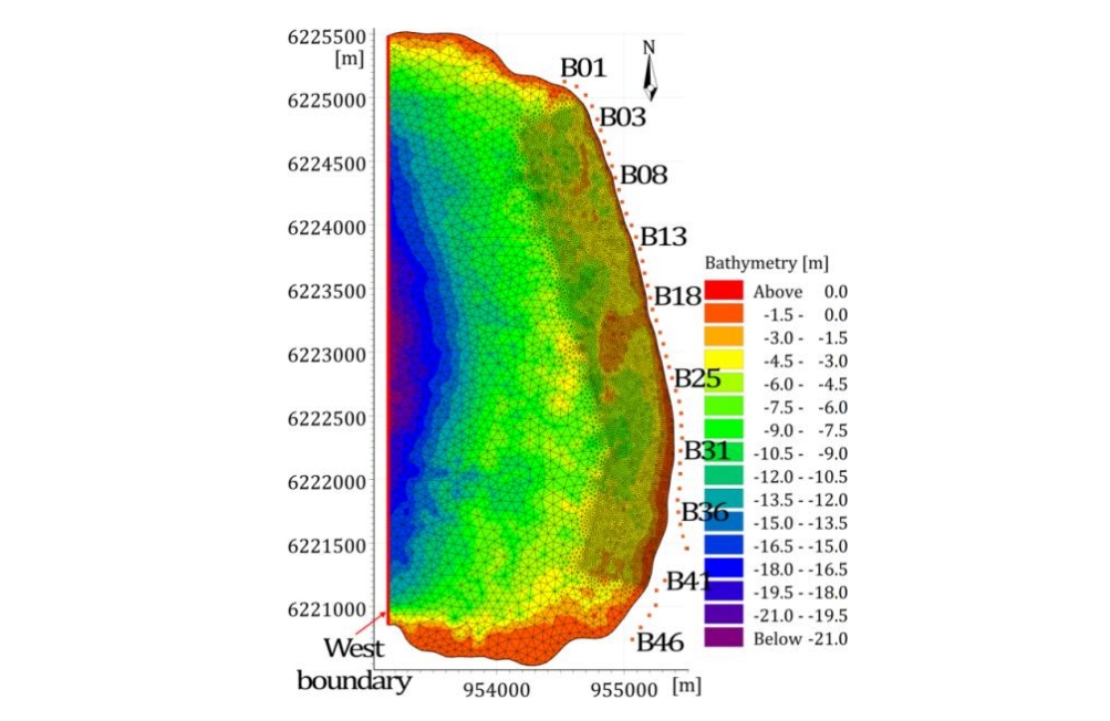
Investigating the effects of sea-level rise on morphodynamics in the western Giens tombolo, France
Rising sea level along with the occurrence of greater and more frequent storms would cause not only coastal flooding, but also beach erosion and shoreline retreat problems. The Almanarre beach…
Multi-Satellite Altimeter Validation along the French Atlantic Coast in the Southern Bay of Biscay from ERS-2 to SARAL
Monitoring changes in coastal sea levels is necessary given the impacts of climate change. Information on the sea level and its changes are important parameters in connection to climate change…
![Timeline for radar altimeters used in our study (modified from [25]).](/sites/default/files/2025-01/radar.png)
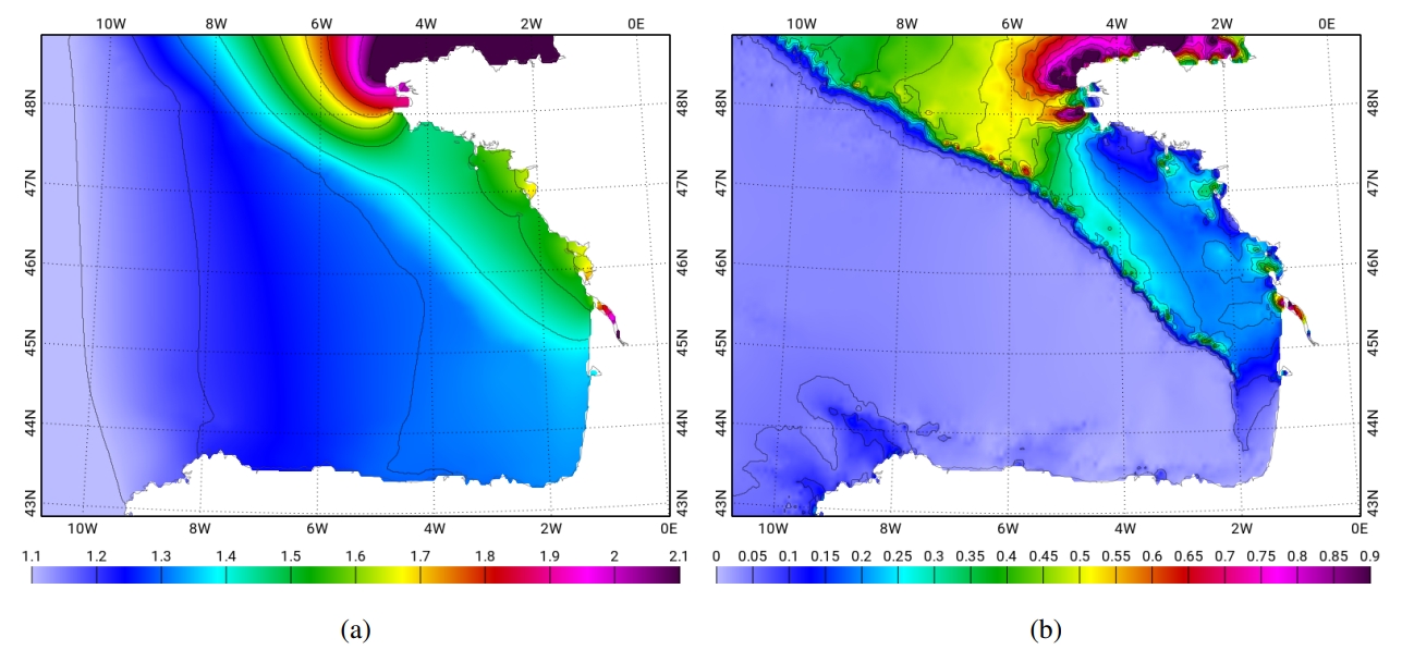
Tidal downscaling from the open ocean to the coast: a new approach applied to the Bay of Biscay
Downscaling physical processes from a large scale to a regional scale 3D model is a recurrent issue in coastal processes studies. The choice of boundary conditions will often greatly influence the…
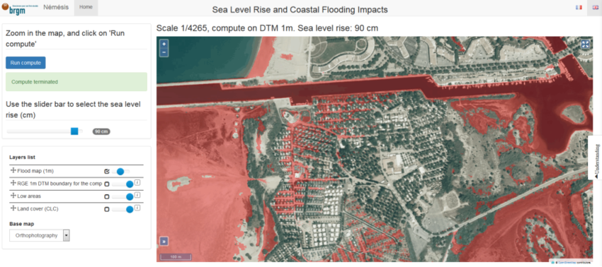
Scalable Interactive Platform for Geographic Evaluation of Sea-Level Rise Impact Combining High-Performance Computing and WebGIS Client
As the climate is changing, more applied information on resulting impacts are required to inform adaptation planning . Over the last decade, the amount of information relevant to climate change…
Casting light on forcing and breaching scenarios that lead to marine inundation: Combining numerical simulations with a random-forest classification approach
Identifying the offshore forcing and breaching conditions that lead to marine inundation is of high importance for risk management. This task cannot be conducted by using a numerical hydrodynamic…

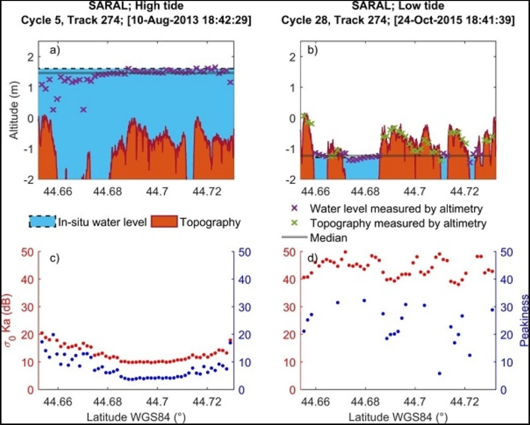
Monitoring Sea Level and Topography of Coastal Lagoons Using Satellite Radar Altimetry: The Example of the Arcachon Bay in the Bay of Biscay
Radar altimetry was initially designed to measure the marine geoid. Thanks to the improvement in the orbit determination from the meter to the centimeter level, this technique has been providing…
Relative Contribution of Wave Setup to the Storm Surge: Observations and Modeling Based Analysis in Open and Protected Environments (Truc Vert beach and Tubuai island)
Recent events like the Xynthia (2010, France) storm illustrate the potentially devastating effect that storm surges can have on the coasts. Nearshore storm surges at the result mainly from two…

Sedimentary Dynamics and Decadal-Scale Changes in the Macrotidal Aulne River Estuary, Brittany, France
Studies of macrotidal estuaries have been dominated by large, high-turbidity systems like the Gironde and Severn, but some macrotidal estuaries are different from these systems. The goal of this…

Assessment of Flooding Hazards at An Engineered Beach during Extreme Events: Biarritz, SW France
This study focuses on flooding hazards along the Grande Plage of Biarritz. This pocket engineered beach, located in the south west of France, was highly battered by a series of storms during the…